Israel = Aggression
Artist: Na’eem Ismail (Palestine)
Dimensions: Approximately 20” x 26”
Circa 1971
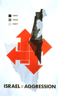
This poster depicts the political and military boundaries of the state of Israel after each of three critical periods, which are color-coded by a legend in the upper left hand corner. The four thick, red interlocked arrows in this poster represent the four points on the compass — north, south, east and west — and graphically emphasize the fact that Israel’s tough and disciplined military forces have advanced victoriously in all directions, even simultaneously, since its independence in May 1948.
The first period (1947), marked in black, represents the boundaries of the Jewish state as defined by the controversial United Nations’ “Partition Plan” of November 29, 1947.
The second period (1948), shown in gray, represents the area reserved under the British Mandate for Palestinians and which was seized and formally annexed by Israel after its War of Independence, fought against Egypt, Syria, and Jordan in that year, thus unifying the whole of the jigsaw puzzle-like mosaic of Mandate-era Palestine under Israeli control.
The light blue zones represent areas conquered by Israel in the Six Day War of 1967 — all of Sinai (Egypt), the entire West Bank (Jordan), and the Golan Heights (Syria).
The Sinai, minus the Gaza Strip, was returned to Egypt in 1978 as part of the Camp David Accords. The West Bank was ceded by King Hussein of Jordan in 1988 to the Palestine Liberation Organization (PLO). According to the failed Oslo Peace Accords, the West Bank and Gaza were supposed to be transferred to the Palestine Authority (PA); however, Israel remains in control of both territories in 2003. The Golan Heights, the western-most region of Syria’s Al Qunaytirah province, was unilaterally annexed by Israel in 1981.
The CIA World Fact Book 2003 specifically states that its maps do not incorporate any of the territories Israel seized in the Six Day War, including the Golan Heights, into its official map of Israel. This decision reflects the American and international community’s refusal to recognize Israel’s annexation as either legal or binding. Israel has constructed more than twenty settlements there, and the Golan Heights remain a source of simmering hostility between the Israel and Syria, which are still technically at war.
This poster, published in 1971, does not depict the area of southern Lebanon — the “security zone” — that was occupied by Israel after its invasion of that country in 1982. Under then-Prime Minister Ehud Barak, Israel unilaterally withdrew from Lebanon in 2000. That frantic, disorderly Israeli pullout was interpreted by many in the Arab world as a military retreat.
The Palestinian-Israeli conflict is, at its heart, a conflict over the land, and accordingly, maps figure prominently in the psychology and propaganda of both sides and can be said to constitute their own sub-genre of posters.
This poster attempts to define Israel’s territorial intentions as aggressive by showing that in each of its wars with surrounding Arab countries, Israel always enlarged its land holdings. It does not indicate any role the Arab countries surrounding Israel might have played in initiating hostilities. Rather, it emphasizes the reality of Israel as the regional military powerhouse, one capable of altering the geopolitical map at will.
© 2003 Liberation Graphics. All Rights Reserved.Questions for A New
Democratic Discussion
1) Do any countries other than Israel have undefined borders? If so, what are the reasons behind the absence of borders?
2) What are some of the major reasons why Israel’s borders remain undefined?
3) Does the U.S. have an interest in seeing that countries have clear, legal, and internationally recognized boundaries?
4) What are the technical differences between the terms “occupation” and “annexation”?
5) Has the U.S. ever recognized any nation’s
claims to lands taken in war? If yes, what were the circumstances? Has
the U.S. ever annexed lands it conquered or seized in war? If yes, what
were the justifications? Were they moral?
Please send us your questions and comments (English only please!)
www.liberationgraphics.com